
The Tomb
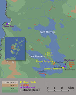
Maes Howe is not only the largest and most sophisticated tomb of the type but is one of the finest prehistoric monuments in Europe. The tomb was built sometime around 2800 BC but it is becoming more and more apparent that the tomb was culmination of a long and complex history of the site. It sits near the southern shore of Loch Harray and was undoubtedly associated with the nearby stone circles at Stenness and Brodgar as well as the prehistoric settlement at Barnhouse and another currently being excavated at the Ness of Brodgar. The entrance passage and inner chambers were cleared by James Farrer in 1861. Further investigations by Gordon Childe in the 1950’s, Colin Renfrew in the 1970’s and Colin Richards in the 1990’s were confined to the mound and the area outside the tomb.
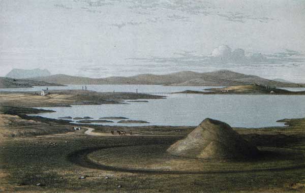
View of Lochs Harray and Stenness showing Maes Howe and the stone circles at Brodgar and Stenness (James Farrer, 1861)
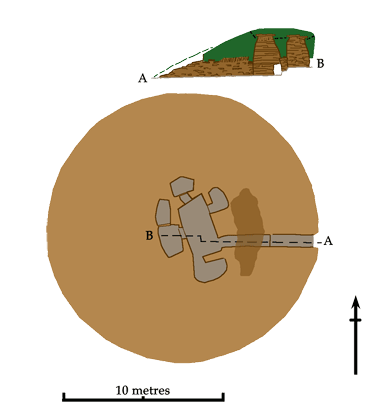
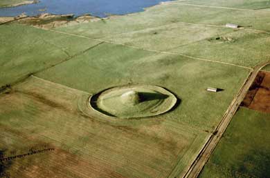
 In the 19th century the tomb was a conical mound, between 28 and 30 metres in diameter and 11 metres high, with a deep depression at the top, sitting on a broad, circular platform surrounded by a ditch. Its appearance was modified somewhat when it was taken into state care in 1910—a concrete dome was installed over the chamber and the top of the mound was reshaped to give it a smoother profile. Today it measures 36 x 32 metres and stands 7.3 metres high. The tomb itself is surrounded by a shallow ditch and a low bank enclosing an oval area about 76 x 60 metres. A survey of the area between the mound and the ditch revealed features under the turf—including a stone-lined pit, possibly for a standing stone.
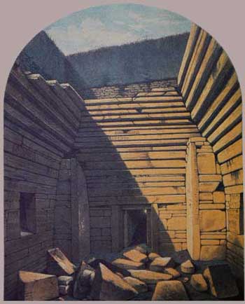
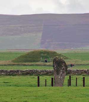
The entrance passage is on the southwest side and is oriented in a direct line with the midwinter sunset—there is a standing stone (the Barnhouse Stone) that marks the line of sight. Every year, for several days on either side of winter solstice, the last rays of the setting sun shine directly down the passage and fall on the rear wall of the chamber. The passage itself was about 16 metres long and is divided into two sections, marked by what appear to be door checks. The outer section is somewhat lower and narrower than the rest. It was 70cm high and 70cm across when it was first cleared. 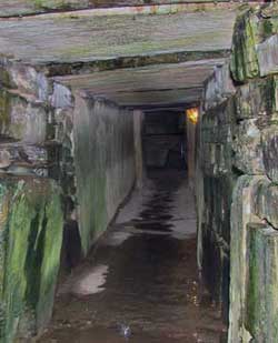
Unfortunately, it was badly disturbed and was modified to a certain extent during the later restorations but from the earliest published sections it is apparent that it had a paved floor and was roofed for at least part of its length. The inner section of the passage, which is on a slightly different alignment, is 1.35 metres high, 1.05 metres wide and 9.5 metres long. For much of this length, the walls were made up of two enormous stone slabs, one on each side, about 5.6 metres long and 1.2 metres high. The outer 2.4 metres are masonry. On the left-hand side, just past the door checks, is a triangular recess a metre high and 60cm deep. A stone was found in the passageway when it was first cleared and it fits neatly into the space. It is generally believed that it was manoeuvred back and forth to either block or open access to the interior as required. Nowadays, the tour guide will usually get a child to rock it gently from side to side to show have easy it can be “walked” into position. Just before the entrance to the burial chamber there are a pair of stones set forward on either side, narrowing the width of the passage to about 70cm. These presumably marked the transition from the land of the living to the land of the dead. Beyond them were a pair of taller uprights which continued the original line of the passage and supported the lintel over the doorway.
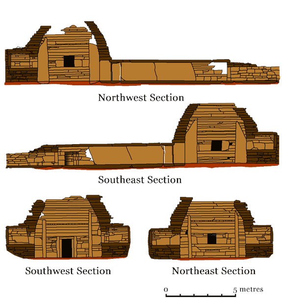
Maes Howe. Cross Sections
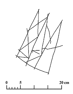
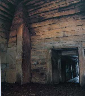 The burial chamber is cruciform (4.7 x 4.7 metres), reminiscent of the layout of some of the houses at Barnhouse. The shallow recesses that formed the arms of the cross were flanked by orthostats ranging in height from 2.4-2.9 metres, which had been built into the walls of the chamber. The south-western stone was engraved with a geometric carving very similar to those found at Skara Brae.
The walls were crafted out of carefully selected stone slabs, some of which run the full width of the chamber. The masonry is superb, the stones all carefully fitted and trimmed to create a flush surface. From a height of about 1.4 metres, the walls were corbelled to a height of at least 3.8 metres, and perhaps as much as a metre or two more (depending on the size of the capstone). We will never know for certain because the capstone and upper courses were removed when the Vikings broke into the tomb nearly a thousand years ago. It is now thought that these stones were originally free-standing and not intended to buttress the masonry of the walls. In fact, they would have weakened the structure not strengthened it.
In the centre of each of the three back walls and at about waist height was the entrance to a side cell. The cells were approximately the same size—from 1.7 to 2.06 metres across by about 1.4 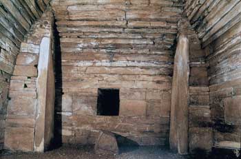 metres deep and about 1 metre high. In each case, the roofs and rear walls are a single slab while the other walls are masonry. The hatches were presumable blocked by the stone plugs that were found lying on the floor of the chamber.
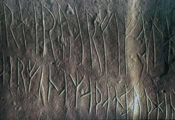
As far as human remains are concerned, only one skull fragment (now lost) was found in one of the cells. Petrie also notes the presence of “a quantity of bones and the teeth of a horse” in the cells. The most likely explanation for this dearth of material is not hard to find. As mentioned above, the tomb was broken into by the Vikings in the 12th century and the tomb was thoroughly ransacked. The walls bear a number of runic inscriptions that testify to this, among them were these:
Crusaders broke into Maes Howe. Life the earl's cook carved these runes. To the north-west is a great treasure hidden. It was long ago that a great treasure was hidden here. Happy is he that might find that great treasure. Haakon alone bore treasure from this mound.
It is surely true what I say than treasure was taken away. Treasure was carried off in three nights before those.
Stone Age farmers had nothing that a Viking would consider treasure which means that the tomb had probably been clear out already and used for the burial of a Pictish or earlier Viking chief. We will never know for certain.
The tomb is covered by a mound of mixed clay and rock fragments that form a very hard, compact matrix about 38 metres in diameter. As was the case at other tombs, it incorporated a couple of low revetment walls as shown in the plan above.
A Henge Monument?
Maes Howe is unusual among contemporary tombs in that it sits on a platform, surrounded by a ditch and an outer embankment. This particular arrangement, especially the interior ditch, is the defining feature of that peculiarly British monument, the henge. However, there is generally at least one entrance to a henge, a gap in the bank and a causeway across the ditch, but there is none at Maes Howe. Investigations directed by Colin Richards in 1991 showed that, unlike other henges,
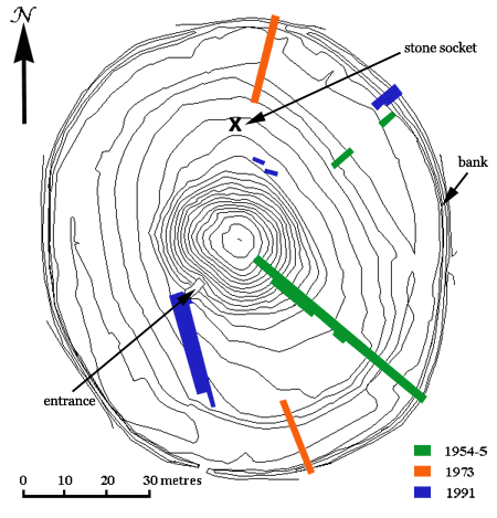
Contour Plan of Maes Howe showing the location of the trenches (contour intervals are at 50cm). After C. Richards, 2005.
the outer bank was not simply the spoil from the ditch but, in fact, a stone wall that stood at least 6 courses high. In fact, judging by the spread of stone in front of it, the wall must have been of considerable height. It was made up of an outer and an inner face of masonry with a rubble core—a type of ‘double wall’ construction well known from Skara Brae and Knap of Howar.
In the course of the same excavations Richards uncovered a drainage channel running away from the entrance passage. It was covered by a flagstone 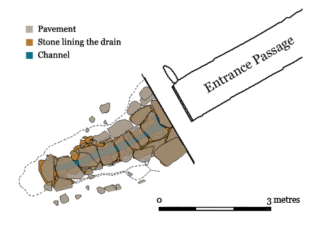 pavement and both ran on the same orientation as the entrance passage but disappeared under the clay of the platform (see plan below). Obviously both features must have been present before the tomb was built and are almost certainly connected with an earlier structure. This building was subsequently demolished and the site was levelled by the addition of clay from the nearby loch to create the aforementioned platform. Next, the four orthostats were dragged to the site and set up in the positions they occupy today, aligned to the midwinter’s sunset. The Barnhouse Stone, which stands over 700 metres away on this same alignment, may well have been erected at the same time but there is no way of knowing for sure.
A resistivity survey of the platform revealed an anomaly below the surface of the platform. On excavation it turned out to be the socket for a substantial standing stone well over 6 metres high, judging by its dimensions. No sign was found of any other stones but that does not necessarily mean that they did not exist. On the one hand, there is a solitary stone beside the nearby tomb at Howe. On the other, there are tombs at Newgrange in Ireland and Clava in Inverness-shire that are enclosed by stone circles. In this particular instance, the stone had been deliberately removed at some unknown point in the past but those involved may not have done as tidy a job with any others that stood there.
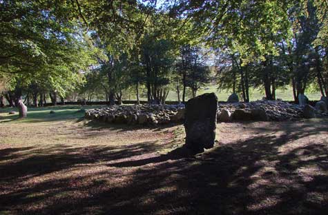
Balnuaran of Clava. Ring Cairn surrounded by a Stone Circle
We have no idea how long the four orthostats were left standing exposed before the rest of the superstructure of the tomb was built. Rectangular settings of free-standing stones known as “Four-Posters” are fairly common in the Grampians and other regions of Scotland and Ireland so there may have been a gap of some time before they were incorporated into the tomb. It is probably that the ditch and enclosure wall were added at this time but it is impossible to say for sure. Its principal function would seem have been to provide a physical barrier—perhaps a moat—separating the world of the dead from that of the living. Both Childe in the 1950’s and Renfrew in the 1970’s ran trenches through the outer bank to examine its profile but these were located in the most disturbed stretches of the circuit.
Suggested Reading: |
|