

When the first western explorers and antiquarians arrived in Mesopotamia Ur of the Chaldees was high on their agenda. After all, it was said by the Bible to be the home town of the patriarch Abraham. As it turned out the site was even more than they imagined. It was the principal 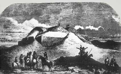 city of a hitherto unknown civilization, dubbed Sumerian by those who first identified it. The image (left) shows the ruins of the ziggurat as they appeared when visited by William Loftus in the 1850s.
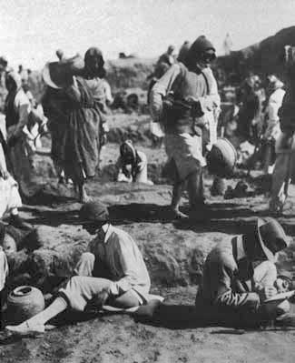
Excavations at Ur began shortly after World War I and were conducted by Leonard Woolley under the sponsorship of the British Museum and the University Museum, University of Pennsylvania. Woolley worked there throughout the 1920's and uncovered huge areas of the city, including the tombs of a number of her kings and queens along with temples, palaces and the homes of ordinary citizens. The results were published over the course of the next several decades.
By the time Hammurabi took the Babylonian throne, in the eighteenth century BC, Ur was already a place of considerable antiquity. It had already been occupied for something like 3500 years, making it one of the oldest cities in the world. Its inhabitants were Sumerians, the people who ‘invented’ the very notion of cities and civilization. Their ancestors were farmers who had moved into the plains of southern Mesopotamia by the sixth millennium BC. It was a fertile land—rich, alluvial soil laid down by the twin rivers, the Tigris and Euphrates—and was enormously productive, provided there was enough water. Rainfall in the region was (and still is) miniscule and it was only through irrigation that its potential could be realized. Unlike Egypt, where the annual inundation comes at the right time of year, before the seeds were planted, the floods in Mesopotamia are unpredictable, difficult to control and come at the wrong time of year (in the spring, at harvest time). In order to harness the power of the flood, an elaborate system of canals, dams and floodgates was developed. The logistical problems were enormous and only the gods had the authority necessary to organize the manpower to do the job. Of course, it was their human deputies, the “Big Men” (LU.GAL) who exercised power on their behalf. As the population steadily grew, a professional class of administers had emerged along with a writing system to handle all of the data generated—invoices, requisitions, ration lists, etc.
Naturally, a lot of the revenue and labour recruited was diverted to keeping the god happy. The result was ever larger and more splendid temples,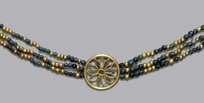 culminating in the great ziggurats that dominated the flat landscape of southern Iraq. Whole industries of skilled craftsmen and artists developed to dress and adorn the gods, and to decorate and furnish their abodes. Of course, their human representatives could not go around looking shabby and living in hovels either. The status of these priestly rulers is clearly evident in the wealth that accompanied their burials in the great cemetery at Ur. The necklace (left) is made of gold and lapis lazuli, both of which had to be imported, in the case of the latter, all the way from Afghanistan.
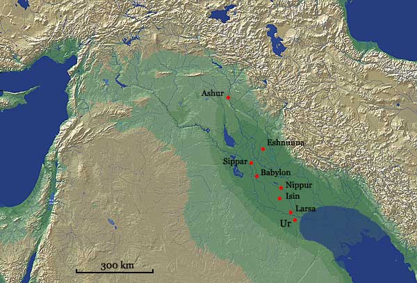
Map of Mesopotamia during the Old Babylonian Period (ca. 2000-1600 BC) showing the approximate extent of the Persian Gulf in those days
The mound of Tell el-Mukayyar, site of ancient Ur, is located on the northern edge of a vast expanse of marshland and saltwater lagoons which gave the inhabitants a variety of environments to exploit and also provided a direct link with the Persian Gulf. The latter was to prove the key to the success of the city for, apart from good soil, Mesopotamia was singularly lacking in most raw materials, such as stone, timber and metals, and had to import them. Most of the population were farmers and herdsmen but significant numbers were involved in manufacturing or trade.
The political fortunes of the city varied over the years but it was always a centre of considerable importance. Its affairs were in the hands of a small group of religious leaders, supported a staff of minor officials and scribes. The priests maintained their position through elaborate rituals and 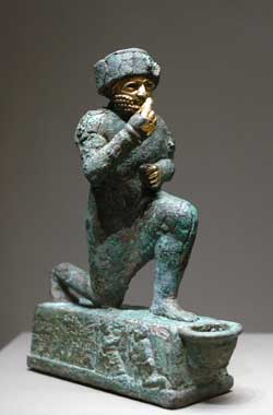 ceremonies designed to promote a sense of community among the citizenry and to reinforce the authority of the gods they served. In fact, the Sumerians believed that the cities in which they lived belonged to the gods and that they themselves were merely their servants. It is therefore not surprising that the grandest and most important buildings in the city belonged to the gods.
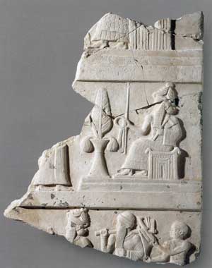
Ur reached the peak of its power in the final century of the third millennium BC, the so-called Neo-Sumerian Period, when it controlled all of Mesopotamia. This glorious episode came to a end with capture and sack of the city by the Elamites in 2004 BC. Its last king, Ibbi-Sin, was dragged off in chains to Susa the Elamite capital and was never heard from again. After the destruction, the survivors eventually trickled back into the ruins of the city and began to rebuild. Although Ur would never again wield power in the region, the prestige of the city meant that it was a valuable prize for those who wished to take her place. The rulers of the rival cities of Isin and Larsa competed in restoring and enlarging the holy places. To the left is a bronze figure with gold leaf decoration depicting a king of Larsa in the act of worship.
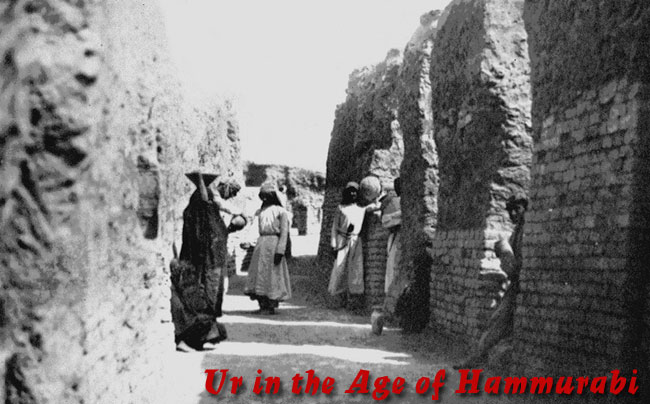
Eventually, like the rest of Mesopotamia, Ur was absorbed into the empire of Hammurabi of Babylon. The city appears to have been quite prosperous during his reign but, along with the rest of ancient Sumer, rebelled shortly after his death. It was captured and sacked by Samsu-iluna, Hammurabi's son, in his eleventh year on the throne (1738 BC).
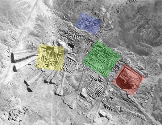
Aerial of the Temenos area during excavations. The colours indicate the areas examined in the text (red for the Ziggurat, green for the Giparu, yellow for the Royal Tombs, and blue for the domestic houses in Area EG
The Temenos
The chief god at Ur was Nanna, the moon god, whose temple was the most conspicuous feature of the urban landscape. It sat atop an enormous stepped tower or ziggurat and was located at the heart of its own walled precinct. This area is known as a temenos (the Greek word for 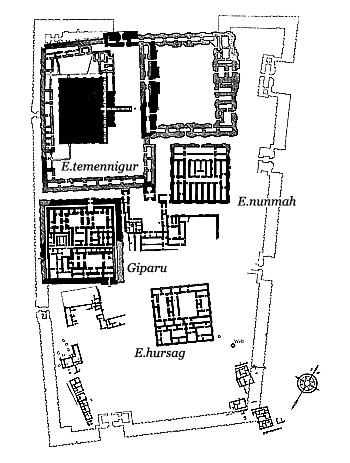 such an enclosure) and, along with the temple, included all of the most important buildings in the town. There was another temple known as the Giparu in honour of Ningal, Nanna's wife, which also served as the residence of the high priestess of the god. The Ehursag seems to have been a royal palace. Most of these buildings date from the time of Ur-Nammu, the founder of the last great independent dynasty of Sumerian kings, although the surviving remains are generally reconstructions belonging to later rulers.
Along with the rest of the city, the temenos area was thoroughly plundered by the Elamites in 2004 BC. Only the ziggurat, because of its sheer bulk, escaped total destruction but the temple at its summit was destroyed along with all everything else that stood in the area. The ziggurat terrace was later restored to something like its old self. A fortified gate was added by Warad-Sin of Larsa, the overlord of the city, to the northwest side of the rebuilt terrace wall but little else was obviously new. The original Edublalmah was laid out by a later ruler, Ishme-Dagan of Isin, but most of what remains belongs to the Kassite Period. The Enunmah was restored to the state it had been when built by Shulgi. The Giparu was restored by Enanatuma (the daughter of Ishme-Dagan and high priestess of Nanna) on the original foundations. Its remains are by far the best-preserved among the public buildings of this period.
Residential Areas
Areas of housing occurred virtually everywhere within the city walls with the exception of the temenos. The most extensively excavated and most coherent plans belong to Areas EM and AH (for their locations, see the city plan). The latest tablets found date to Year 11 of Samsu-iluna, known as the “year in which the King destroyed the walls of Ur”. Although the houses in these neighbourhoods had been occupied from the beginning of the second millennium BC, the destruction ensured that those of the very last phase were especially well-preserved and enabled Woolley to get a reasonably accurate picture of life in the city at a particular point in time.