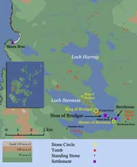

The Ness of Brodgar sits right at the centre of the World Heritage site known as the Heart of Neolithic Orkney, designated such in 1998 because of the number, scale and variety of prehistoric monuments in the immediate vicinity. Within the larger area are two smaller ones known as Inner Buffer Zones. Zone 2 includes the area around Skara Brae while Zone 1 is defined by a pair of lochs on either side of a narrow isthmus known as the Ness of Brodgar.
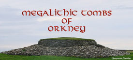
At the time the heritage site was defined, Zone 1 included a number of Neolithic and Bronze Age tombs, the most magnificent of which is Maes Howe; two major stone circles/henges, the Stones of Stenness and the Ring of Brodgar; numerous standing stones (including both solitary uprights and others that are clearly in some sort of rough alignment); and one important settlement known as Barnhouse, being at the centre of what seems to have been a natural meeting place for the inhabitants of the islands It is readily accessible by both land and sea.
While Harray is a freshwater loch, Stenness is open to the sea. The distinction is yet another dualistic element in the Neolithic cosmology, along with day/night; male/female; life/death; summer/winter;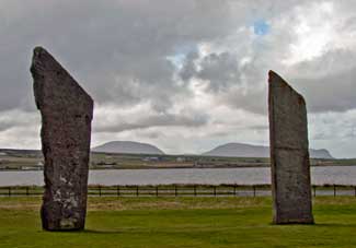 good/evil; etc. This dualism is also evident in the nature of the settlement in the islands, the tomb architecture and the type of pottery in use. However, it is not strong enough to indicate that there were two different tribes operating in Orkney, or that there were two separate ‘waves’ of immigration. In fact, there is little to suggest that the changes should not be attributed to purely local development.
The countryside surrounding the Ness is fairly flat and there are panoramic views in all directions. In the middle distance, a ring of low hills with a radius of 2 or 3km. encloses the principal monuments but the defining feature is the Hills of Hoy (Ward Hill and the Cuilags) several kilometres further away to the south. They are not much above 300m but, even so, are the highest points of land in Orkney and are highly visible from all over the islands. You can see them in the background of the view from the Stones of Stenness (above left). It was a natural meeting place— the Hoy Hills are visible from virtually anywhere in the islands.
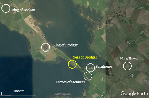
GoogleEarth View of the Heart of Neolithic Orkney (Image ©2017 Digital Globe)
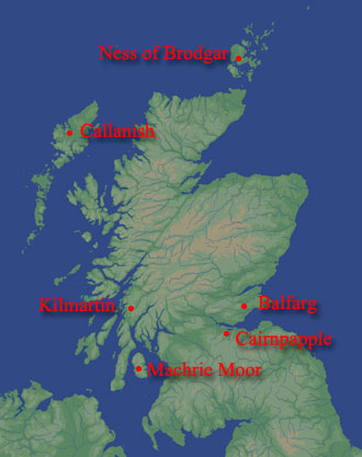
Such a landscape was a powerful attraction to the small farming communities of the Scottish Neolithic and similar assemblages of sites can be found at Callanish, in the Outer Hebrides; in Kilmartin Glen in Argyll; and (possibly) at Cairnpapple in West Lothian. They appear rather late in the Neolithic, when the social arrangements among the small communities that first settled Scotland, became more complex— most likely due to population pressure and dwindling resources.
Henges & Stone Circles
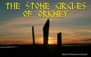
Henges, which can defined as a roughly circular ditched enclosure with an external bank, begin to appear in the late fourth millennium BC and there are four of them in the immediate vicinity. Both the Ring of Brodgar and the Stones of Stenness began as henge monuments before the stones were added. Beyond Ring of Brodgar to the northwest is 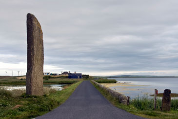 another ditched enclosure, the Ring of Bookan, that was most likely a henge (although no entrance has been found). It is at about the same distance (ca. 1.5km) from Brodgar as the Stenness monument is and is about the same size, moreover the three are roughly in a line. There are a number of standing stones between Brodgar and Stenness (a number of which were later destroyed by landlords in the early modern period. A pair of them once flanked either side of the southeast end of the narrow isthmus separating the two sites. One of these, the Watch Stone (shown, left, looking NW to the Ness of Brodgar), still stands but its companion is represented by an empty socket. There are another pair a little further along, in the front garden of Lochview house— although these are aligned along the line of march between the two sites rather than on either side. It cannot be said for certain that these mark a processional route, similar to the avenues at Avebury far to the south in Wiltshire, where at least one of them links the main site to a smaller circle known as The Sanctuary (see the drawing below).
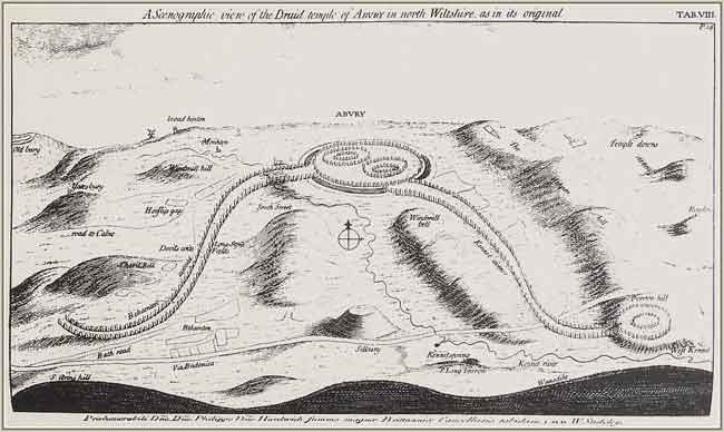
Scenographic view of Avebury by William Stukely (1687-1765)
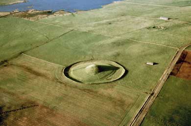 There is one more henge-like monument in the immediate vicinity and that is the great tomb of Maes Howe. The term “henge-like” is used because, in the first place, there does not appear to be an entrance, which is a defining feature of the type, and, in the second, instead of an outer bank made up of spoil from the ditch there is a stone wall. Recent exploration suggests that originally there had been a structure of some sort at the site which was later replaced by a setting of four orthostats which were susequently incorporated in the construction of the tomb chamber. The ditch and enclosure wall were most likely built at about the same time.
Barnhouse
In 1984 the remains of a small settlement was discovered at Barnhouse about 150m north of the Stones of Stenness, on the shore of Loch Harray. The remains of 15 buildings (not all contemporary) were uncovered representing a community that lasted 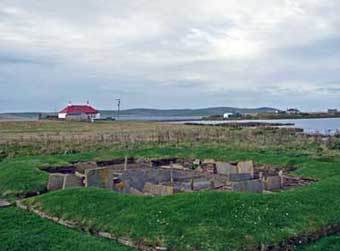 for perhaps a couple of centuries, from ca. 3050-2850 BC. The Ness of Brodgar site was occupied throughout this period, an occupation that began somewhat earlier (how much earlier is yet to be determined) and lasted two or three centuries later.
Architecturally, the buildings were very similar to the houses of the earlier period at Skara Brae. However, the layout of some of the houses was distinctive. One of them, House 2 (left), is larger and more elaborate than the others suggesting its occupant may have been accorded more status than the rest. Such a hierarchy of settlement was not apparent at Skara Brae. It has been plausibly suggested that the village was the residence of the custodians of the nearby stone circle, priests if you like. House 8, which was built ca. 2600BC, after the rest of the settlement had been abandoned, has been described as a Neolithic temple. It was a massive, square structure with thick, double walls and a central hearth and the whole was enclosed by a massive outer wall.
Summary
By the end of the twentieth century a picture had emerged of an increasingly complex society, with a powerful system of beliefs that were made manifest in the architecture of the tombs and stone circles erected during this period. The sheer effort involved was enormous— not just the quarrying, transportation and erection of the stones— but all of the ancillary activity that went along with it. Ropes were needed, along with timber for sledges, rollers, levers and cribs; and everybody needed to be fed. In terms of the number of man-hours (not to mention woman and child-hours) something on the scale of the Ring of Brodgar could be reckoned in tens if not hundreds of thousands. Obviously, a great deal of organization involving an extensive network of social relationships was required but the extent of these arrangements could only be guessed at. However, this state of affairs would change rather suddenly with the discovery of the Ness of Brodgar site at the start of the new millennium.
Suggested Reading
| Card, Nick | (2011) | Ness of Brodgar, Stenness, Orkney Excavations 2011 Data Structure Report, ORCA 271. |
| Davidson, A.L. & A.S. Henshall | (1989) | The Chambered Cairns of Orkney |
| Garnham, Trevor | (2004) | Lines on the Landscape, Circles from the Sky |
| Renfrew, Colin (ed.) | (1985) | Prehistoric Orkney |
| Richards, Colin. (ed.) | (2005) | Dwelling among the Monuments |
| (2013) | Building the Great Stone Circles of the North | |
| Richards, Colin & Richard Jones (ed.) | (2016) | The Development of Neolithic House Societies in Orkney |
| Wickham-Jones, C. | (2006) | Between the Wind and the Water. World Heritage Orkney |