
It has been argued that the original intention was that the troops who manned the Wall would be permanently based in the Stanegate forts and that small detachments would be sent to man the mile castles on a rotating basis. Support for this position lies in the fact that a number of forts overlie a pre-existing mile castle or turret. However, in the case of Housesteads, the fort was apparently built after the broad foundations of the Wall but before it was completed on the narrower gauge. The fact that there was already a turret on the site may have been a simple 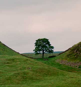 matter of planning error—it was a huge and complex project after all.
It is hard (although not impossible) to believe that Roman generals would opt for a plan with so many liabilities. In the first place, the road often diverged some distance from the Wall and for long stretches the River Irthing or the Eden separated the two. This would have made it unnecessarily difficult to move troops up to the Wall in an emergency. Then, when they got there, they would have been faced with the problem of funnelling large numbers of men through relatively narrow openings. In any case, there is very little interval between the commencement of the Wall and the completion of the first forts, so it is probably safe to assume that they were part of the original plan.
Sixteen forts are known, running from South Shields at the mouth of the Tyne to Bowness on Solway Firth. From inscriptions we know that Benwell and Halton Chesters were built during the governorship of Aulus Platorius Nepos which ended in AD 126 but others may have been completed sometime later. Although they varied in their details and size, ranging from 1.35 to 3.75 hectares in area, the forts were normally of the 'playing card' type—rectangular with rounded corners.
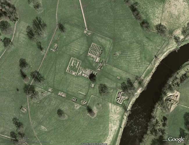
GoogleEarth View of Chesters (note Bath House on left bank of the river, opposite the bridge abutment)
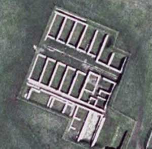
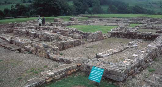
They were essentially the standard marching camp, with the usual praetorium; principia, barracks, etc. (see the plan of Wallsend, below), but permanent. They also possessed certain additional structures—latrines, granaries, workshops, hospitals and bath houses—that the camps lacked. The ramparts were usually of stone backed by a sloping earthen bank although occasionally they were made of turf and timber. In fact, the ‘playing card’ shape is more appropriate to the latter which were very vulnerable at the corners. The fort was usually surrounded by a ditch with a V-shaped profile but that was not always the case— sometimes the steepness of the slope made one unnecessary.
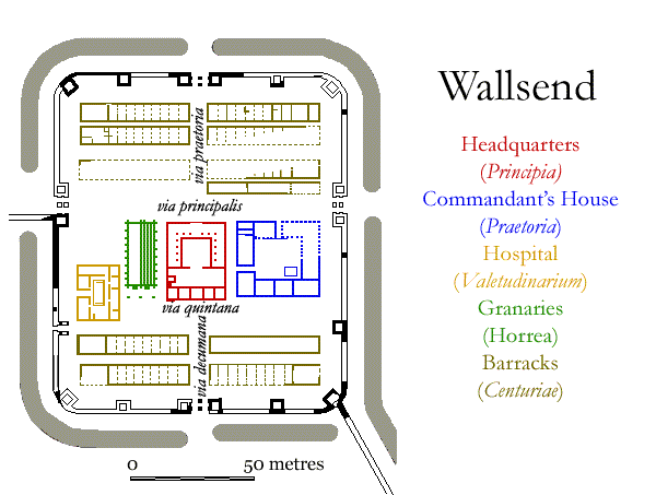
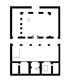
Ground Plan of Wallsend Fort
The size of the forts depended on the number and composition of the units— usually a cohort of infantry (480 men) or an ala of cavalry (500 or 1,000 men + mounts)— but mixed units were not uncommon. Obviously, the cavalry units would require much more space because of the horses. The largest fort, Stanwix, was home to at least part of the ala Petriana millaria, one of the larger units. In typical military fashion, the new forts were fairly evenly spaced along the length of the Wall (between 5½ and 9½ Roman miles), with no apparent regard for natural strong or weak points in most cases—although river crossings could not be ignored. Where possible, they lay astride it so that three of their four gates opened to the north enabling the garrison to move out rapidly should circumstances require. Their positioning (and the nature of their defences) suggests that they were not meant to serve as defensive strongholds but as fortified bases for launching pre-emptive strikes. The Roman army of the time was simply not organized or equipped to fight a defensive war.
Gateways & Streets
Normally there would have been four double-portalled gateways—one midway along each of the short walls and one about one-third of the way along each of the long sides, where the via principalis, ran through the fort. The gates were protected by flanking towers and there were a number of turrets, generally spaced halfway between each gate. As was the case along the Wall, 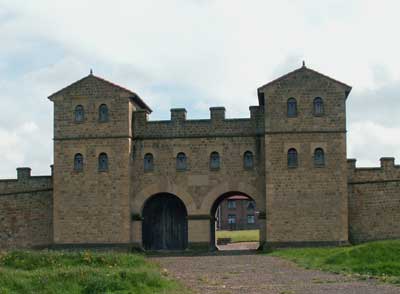 they projected inwards and had little military value beyond serving as watchtowers. They did not provide flanking fire covering the face of the curtain wall nor were they suitable to mount artillery, such as ballistas and the like.
The main gate was the porta praetoria. From here the via praetoria ran straight to the front of the headquarters’ building, the principia, which stood just about at the centre of the site. On either side of the principia were the commanding officers quarters, the praetoria, and the granaries, or horrea. Along the front of these buildings and at right angles to the via praetoria ran the via principalis, which linked the two side gates— the porta principalis sinistra and the porta principalis dextra. Behind the main buildings and parallel to the via principalis was the via quintana, while running from the rear of the principia and continuing the line of the via principalis was the via decumana, which led to the porta decumana. The area between the buildings and the ramparts, the intervallum, was kept clear to permit rapid movement of troops.
The Principia (Headquarters Building)
The headquarters building was divided into three main sections—a courtyard with verandahs on three sides, a basilica, typically consisting of a nave and one aisle, and a range of rooms at the rear of the building. The entire garrison could assemble there if need be. The main hall of the basilica was illuminated by 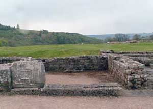 clerestory windows high in the walls. At one end, the left-hand one as you entered, was the tribunal, a platform from which the commanding officer would address his troops. The room at the rear of the building was the aedes, the shrine where the unit’s standards were kept along with other religious and ceremonial objects. The room was open at the front, separated from the nave by a screen wall of decorated slabs of stone (such as the one that survives at Vindolanda– left) and with an iron grill.
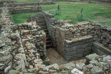
The rooms to either side of the aedes were the offices of the adjutant (cornicularius) and the standard bearers (signiferi). At Chesters among other places, the rooms next to the shrine had counters with iron grillwork, which were the only access to the inner office next door. The signiferi were responsible for pay and to handle any banking needs the legionaries might have. A set of stairs in the shrine gave access to a basement strong room where, among other things, the pay for the legionaries was kept.
The Praetorium (Commandant's House)
The Praetorium at Vindolanda
The house of the commanding officer was based on the typical Mediterranean atrium house favoured by the Roman ruling classes—no concessions at all were made to local conditions. Villas were designed to provide shade and escape from the heat, and consequently the living quarters 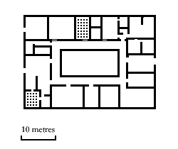 were arranged around an open courtyard. As commanding officers—and their families—came and went, the building would have been modified and remodelled to suit the new occupants. Common modifications were the building of hypocausts (sub-floor heating systems) and the addition of a bath-house, so that the family would not have to mingle with the common soldiers. All of this remodelling means that it is difficult to reconstruct what when on in the various parts of the house. A bedroom in one phase of occupation may have been converted to a kitchen in another. Its fairly obvious that the domestic areas would have been closest to the hypocausts. Bathrooms would have been provided with proper drainage and have been identified at a number of sites on the basis of paved floors and clay piping systems. The kitchen would have been in the back corner of the building, preferably on the downwind side, where its ovens and braziers provided additional heat. The domestic suites consisted of reception rooms, dining rooms and sleeping quarters for the family and for important guests— other commanding officers, provincial officials and the governor himself on occasion.
The Valetudinarium (Hospital)
The identification of the fort hospital is not quite as straightforward as the others. The location varies and there is little to distinguish many of the ones that have been identified from workshops. The Valetudinarium at Housesteads is the only one that has been thoroughly explored.
Horrea (Granaries)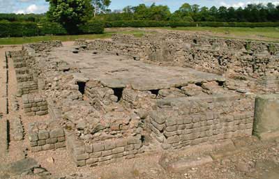
The granaries (there was normally a pair) are fairly easy to identify. They were buttressed buildings with raised floors set on a series of piers or low walls with openings to permit the circulation of air underneath. The reconstruction of the superstructure is somewhat speculative. A central aisle with rows of bins on either side seems plausible but then so does sacks of grain in one big room. There was normally a loading bay at the via quintana end of the building. Provisions would have been purchased locally as far as possible, but many items (such as the ever popular fish sauce) would have had to be imported. Transport was normally by wagons drawn by oxen, which was very expensive.
Barracks and Stables
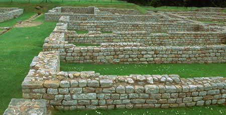 The rest of the fort was taken up by barracks for the men and stables for the horses. Typically, Roman barrack buildings, such as the one, left, at Chesters, were based on the tent lines of the camp. The basic unit of the Roman army was the contubernium of 8 men. They were essentially a mess unit, sharing a single tent and cooking their meals in common. In the permanent fort, each of these units was assigned a room in a centuriae, a barrack block designed to accommodate a century of men. Normally that meant a total of ten rooms. On the march, a large box tent was set up for the centurion and in the barrack block he would have occupied the additional large set of rooms at the end of the building nearest the ramparts. These were spacious enough for his family and servants. Each of the other rooms was sub-divided into a small front room (arma) where the soldiers kept their equipment and a rear room (papilio) for sleeping.
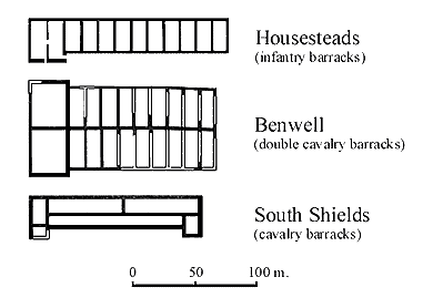
Barracks often faced each other, their slope roofed verandahs designed so that water would run off into a common drain. The earliest ones were probably made entirely of timber but most of them were eventually rebuilt with stone foundations if not entirely in stone.
The arrangements were a little different for cavalry units where two turmae of 32 men each were housed in 8 rooms. Since there would have been two officers (decurions) to house, each of these had his own suite— often at opposite ends of the building. No obvious stables have been identified— perhaps the horses were kept in modified barracks buildings— nor has anything like a vehicle park for the various carts and wagons required by the unit.
Other Buildings
A garrison of several hundred men needed more than just food and lodging. Communal latrines and bath houses were absolutely necessary, not only for sanitation and hygiene but for socializing as 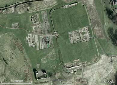 well— the Romans were not particularly squeamish about their bodies and bodily functions. A good set of latrines has been investigated in the south-eastern corner of the ramparts at Housesteads, taking advantage of the natural drainage.
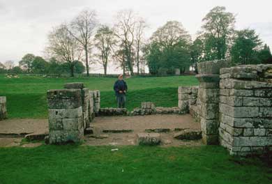
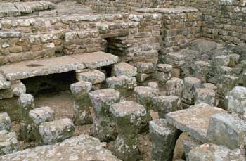
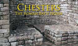
Because of the inherent danger of fire in the bath houses, these tended to be located outside the fort. There is a particularly well preserved example at Chesters (click the link, right).
The Vicus
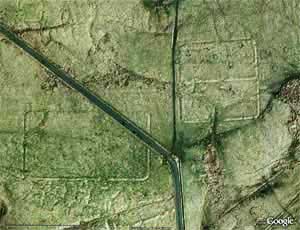
As the forts became permanent fixtures, civilian settlements (vici) grew up outside their walls with a variety of establishments to look after the needs of the men. A satellite image showing the settlement outside the fort at Vindolanda is shown above. Legionaries were forbidden to marry, so none of them had wives with them. This meant that— in addition to buying their own needles and thread— the men had to find companionship and entertainment elsewhere. Workshops, taverns, gambling dens and brothels have all been identified.
The Vallum
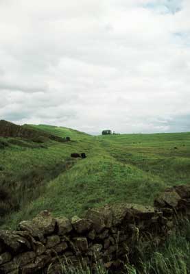 Sometime after construction of the forts had begun, a decision was made to add another element to the defensive system—known today as the ‘Vallum.’ It was an earthwork, consisting of a flat-bottomed ditch 6 metres across and 3 metres deep, flanked by a pair of linear banks, themselves about 6 metres wide, set back 9 metres from the top of the ditch.
It runs east to west at varying distances from the Wall and was clearly built after the forts since it swerves to avoid some of them. The ditch was crossed by causeways (controlled by gates) to allow access to the forts and seems to have been designed, in part, as a barrier to the south. Civilian traffic would presumably cross at one of these causeways and then make their way to one of the mile castles to pass through the Wall (it is hardly likely that they would have been allowed to drive their herds through the forts). The Vallum severely restricted the number of routes through the Wall that the local tribesmen could use—from about 78 to perhaps 15—thus giving the army much more control over their movements. It may have been constructed in response to an emerging threat from the south but, unfortunately, we do not know the details.